Historic Wyre Forest
Background to the Historic Environment of Wyre Forest
Wyre Forest is located in a valley landscape that has widespread signs of early prehistoric activity and seasonal settlement. While excavations at a settlement site in Blackstone, near the river town of Bewdley during the 1970’s proved that Iron Age settlement was found here during the 2nd to 1st century BC, overall there has been a lack of linked local landscape signs for land-use during the Iron Age and Romano-British periods. There are notable settlement sites that are found at the edges of the current forest; the Roman fort and settlement at Wall Town and the promontory enclosure in Wassell Wood.
By the medieval period, control of the land of Wyre Forest changed between royal and manor ownership with large areas of park enclosed. The spread-out settlement pattern of Wyre probably began to develop at this time along with signs of early iron workings near to Baveney Brook. Industrial use of minerals, woodland goods and settlement continued to develop and expand during the post-medieval and modern periods. Following the building of the Bewdley to Woofferton railway line in 1864, fruit growing, forest crafts and deep coal mining grew during the 19th and early decades of the 20th century followed by a rapid failure, which included closure of the railway line in 1964.
The map browser for the Wyre Forest GIS has now been retired however you can still access all of the data by contacting the HER – follow the link below and choose Archaeological advice and information, then Historic Environment Enquiry.
The Grow With Wyre historic environment programme
Grow With Wyre was a Heritage Lottery Fund, Landscape Partnership Scheme that ran from 2008 until 2012. Grow With Wyre delivered 18 projects under 5 themes:
- Habitat Protection and Restoration
- Landscape Character and Heritage
- Sustainable Energy
- Education and Skills
- Access
Historic environment projects, including a Lidar survey, were part of Programme 2.
Lidar Survey
The LiDAR survey of Wyre was carried out by a light aircraft that flew over the project area in March 2007. The aircraft was fitted with survey equipment that sends out many lasers towards the ground surface. The lasers hit the surface and bounce back to the aircraft which allows the equipment to record a location and height point for each laser, together the points create a map of the ground surface as well as buildings and trees. A computer can then be used to take away the points for buildings and trees, leaving just the ground surface which will show archaeology hidden beneath the woodland.
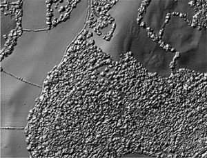
LiDAR survey showing tree cover
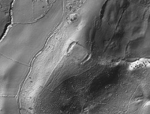
Tree cover removed revealing Iron Age enclosure
The survey revealed over 2000 ground surface sites that could be archaeology. Between 2012 and 2013 a volunteer-led survey checked over 1300 of these features on the ground and recorded them in detail. Read the report about the work of the volunteers below.