Historic Environment Research
Worcestershire Archive and Archaeology service has undertaken a number of research projects to better understand the heritage of Worcestershire and its significance. This research has fed into the Historic Environment Record as well as producing a number of separate resources for example the Worcestershire Ceramics Online database, Historic Landscape Characterisation and Worcestershire Research Framework for the Historic Environment. The following page provides details of these research projects alongside links to additional resources.
Worcestershire Archive and Archaeology Service undertook a Historic Landscape Characterisation (HLC) of Worcestershire as part of Historic England’s national programme of Historic Landscape Characterisation. The project had the aim of better understanding the County’s landscape as the setting of the archaeological sites and monuments within the Historic Environment Record.
The Worcestershire HLC is accessible via an interactive map browser below and is fully integrated with the Worcestershire Historic Environment Record. The resource can be used to provide a basis for landscape management, place planning, development control and conservation issues at a local, regional and national level.
Historic Landscape Character Map Website
Historic Landscape Character Report (Includes guidance on applications of HLC)
Our ceramics database was designed to make the complete pottery fabric and form type series for Worcestershire accessible online. The database is aimed at ceramic specialists and students, but can be used by anyone interested in the study of pottery, as it includes both simple and advanced search facilities.
It contains information on all pottery used and made in Worcestershire from the Neolithic to the early post-medieval period, as well as the most commonly identified later post-medieval and modern fabrics and forms. Also included are high-resolution fabric images and concordance information for other type series in surrounding counties.
Many of these 18th and 19th-century maps of Worcestershire and their associated documents have been digitised. Together with the other records within the HER, these form part of a powerful, searchable research tool.
Download our Worcestershire maps guide
We rely on external funding to undertake this work, and new maps are being added as they are completed. If you belong to a local history, archaeology or community group we may be able to assist your organisation to apply for a grant to allow this work to continue as part of a group/community project. We have already worked with Badsey and Aldington, Stourport and Hanley Castle on mapping projects and the results are available on their websites.
An archaeological survey of the historic towns in Worcestershire, Herefordshire and Shropshire was carried out by the Worcestershire Historic Environment and Archaeological Service in 1992-1996. Archaeologists studied all the available sources of information about each town – archaeology, history, buildings, maps, finds – and developed an understanding of what each town looked like in the past. Thirteen historic towns were assessed in Worcestershire: Alvechurch, Bewdley, Broadway, Bromsgrove, Clifton-upon-Teme, Droitwich, Evesham, Kidderminster, Pershore, Redditch, Stourport-on-Severn, Tenbury Wells, Upton-Upon-Severn.
The reports for towns in Worcestershire, Herefordshire and Shropshire are available online via the Archaeology Data Service website.
Developed in partnership with Historic England, ‘Your Place Matters’ covers community planning for the future of rural buildings in their setting, helping to shape the scale, style, form and location of new development, as well as identify opportunities presented by the natural and historic environment. Learn how to inspire and guide future change with our free toolkit for community groups, non-heritage professionals and researchers.
Historic farmsteads and their buildings contribute to local distinctiveness and the varied character of our countryside by reflecting local geology, building traditions and farming practices. The future of the majority of historic farm buildings is increasingly dependent on a new role outside mainstream agricultural use. Since 2009 Worcestershire County Council has been involved with a series of Historic England funded projects aimed at enhancing understanding of farmstead character and survival within Worcestershire, and the wider West Midlands region, and developing conservation guidance that can be used to inform the sustainable development or re-development of historic farmsteads and their landscapes. The work undertaken will also be of significance to those with an interest in the history and character of the county’s landscape, settlements and historic buildings.
The following guidance aims to inform the sustainable development of historic farmsteads and landscapes, as set out in both national and local planning policy.
Worcestershire Farmsteads Assessment Framework – a step-by-step approach to considering the reuse of traditional farm buildings and the sustainable development of farmsteads, through identifying their historic character, significance and potential for change. The guidance will help to identify the need and potential for change and then prepare a scheme based on considering: The landscape context, the whole site, the extent of historic change to the whole site and its landscape context and architectural patterning.
The Worcestershire Farmsteads Character Statement – fully-illustrated guidance on the county’s farmsteads.
Guidance on Recording and Research – guidance to help applicants and local authorities to consider the most appropriate level for the recording of a site, either in support of an application or, once permission has been secured, to make a record during the implementation of a scheme.
Farmstead Character Area Summaries – the areas, into which the county subdivides, based on analysis of its farmsteads in their landscape context.
Local Authority Summaries – a summary for planners and applicants in each of the county’s local planning authorities.
The Worcestershire Research Framework for the Historic Environment website has been created as part of a national strategy to create a series of self-sustaining Research Frameworks for England. Funded by Historic England, the website is intended to promote cross-sector and community collaboration. It is a developing resource that will expand to incorporate a series of period-specific Resource Assessments covering Worcestershire’s archaeology and landscape and the built environment. At present the website incorporates research questions related to Built Environment: Buildings and Landscapes, Built Environment: Worcestershire Farmsteads, Built Environment: Modern, Archaeology and Landscape: Palaeolithic and the Early Medieval Research Framework.
Worcestershire Archive and Archaeology Service undertook a project aimed at judging the impact of flooding and flood-prevention on the County’s special historic environment and landscape character. Worcestershire is mostly vulnerable to surface and watercourse flooding, with large areas of the countryside, including many historic towns and villages, being regularly subject to flooding. The harmful impact of flooding on historic environment features and character can be significant. Furthermore, flood prevention work can have an impact on historic environment character and individual heritage sites, and may push flood waters elsewhere downstream, spreading damage to heritage sites. Surface water flooding from secondary water courses and factors such as overland flow is also a common threat.
More details including links to report can be found in the project archive.
Between 2018 and 2020 work was undertaken to identify, record and better understand the significance of 20th Century buildings and public places across the County. Many more await discovery and assessment!
Funded by Historic England, this project also aimed to strengthen the public’s awareness and appreciation of ‘everyday’ 20th Century heritage, its conservation, value and significance.
From County Small Holdings and Schools to Village Halls and National Chain Stores the project explored the diverse range and legacy of our 20th Century heritage and celebrated the extra layer of richness it brings to both our lives and landscapes.
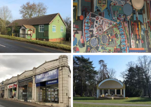
Early 20th-century prefabricated, corrugated iron village hall in Pensax (top left); Mosaics by Sir Eduardo Paolozzi in the Kingfisher Centre, Redditch (top right); Bandstand in Brinton Park, Kidderminster built in 1934 (bottom right); 1930s shopping parade in Malvern built in the Art Deco style (bottom left).