Manorial Documents Register Project June 2014: The Landscape of the Manor
- 24th June 2014
This month, in order to set the documents covered by the Manorial Documents Register project in context, we will look at what a manor looked like in the landscape. This is a really brief overview, but if you wish to find out more, lots of exciting work has been done by archaeologists and historians—please do come along to The Hive to explore the resources in our Local Studies and Archaeology Library, as well as archives and the Historic Environment Record.
In theory and popular imagination, the medieval manor was a self-contained system, governed by a lord under the jurisdiction of his court. Peasants produced food and resources for themselves and for the lord’s household to consume and sell surplus. Reality was not always so clear cut, however. Market production, trade and contact with other settlements, including towns and other manors in a big estate, was more extensive than previously believed, and manors became less self-sufficient with time.
The shape, size and composition of a manor varied through time and depended on the local geography, economy and jurisdictional arrangements. In some upland or rocky areas of the country, manors were long and thin, or consisted of scattered parcels of land and resources. A more ‘typical’ manor, however, is often imagined as a village, consisting of the manor house and outbuildings, peasant dwellings, perhaps a church, a mill, and some fishponds. This compact or nucleated settlement would be surrounded by fields, pastures, meadows and woodland.
This type of compact unit did exist, and there are Worcestershire examples, particularly in the south east and central east of the county. We must remember, though, that manors could contain more than one village or parish and vice versa. The manors forming the large estate of the bishops of Worcester often contained one or more complete settlement, as at Alvechurch and Hartlebury. The county also included many hamlets and other dispersed settlements.
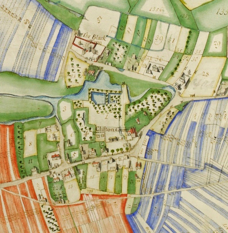
This is a detail of a mid-18th century map of Clifton manor in the parish of Severn Stoke, by John Dougharty. The map was made prior to enclosure: note the manor house, tenant houses and ponds surrounded by fields divided into strips. Meadows are represented elsewhere on the plan. Clifton was part of the estate of the Earls of Coventry. This document is held by Worcestershire Archive Service and can be viewed in the Original Archive Area at The Hive at reference x705:73/BA14450/246.

Imaginative illustration of Grafton Flyford during the 14th century. Illustration by Deborah Overton
The following list gives an idea of what might be found on a manor, but it is not exhaustive, and not all manors contained all of the features described.
Capital Messuage
Demesne
Land let to tenants in return for rent and/or labour services
Land and land use
Open Fields
The term ‘open fields’ does not just mean land that was unfenced—it also usually implies communal[1] use of land (especially pasture) and cooperation in cultivation and animal husbandry, according to by-laws set out in the manor court. During the middle ages, a crop-rotation system of agriculture was prevalent, where one field would lie fallow to prevent soil exhaustion while the other one or two were cultivated. Different fields would be used for growing different seasonal crops, such as corn, wheat, rye, barley, peas, beans and oats. Before the Black Death, a two-field system of agriculture, with one field left fallow, was used in south east Worcestershire, but there was flexibility—for instance, after the harvest, arable fields could be used for grazing.
Fields were divided into furlongs and further subdivided into ploughstrips held by individual tenants and ploughed by teams of oxen.[2] The strips were divided by un-ploughed raised, grassy ridges, or marked by stones in the 16th-century manor of Elmley. Peasants’ strips would not be concentrated in a compact block, but scattered throughout the open fields, to ensure that each holding would contain a mix of lands of different qualities. The lord’s demesne strips would often be scattered amongst those of the tenants.
The remains of medieval agriculture may still be seen in the form of earthworks known as ridge and furrow. These, and the remains of shrunken or deserted villages, can be seen in aerial photographs and a technique known as LiDAR.
The landscape began to change during the later medieval period, particularly the fifteenth century, as tenants began to consolidate these strips into single holdings by exchanging land with other tenants, and enclosing the new bigger parcels of land. These enclosures could then be used as pasture or meadow in addition to arable.
Pasture and Meadow
Manors had common pastures, shared by lord and tenants, as well as individually held pastures. Pasture became more important from the late medieval period right up to the 18th and 19th centuries, as sheep farming became more profitable. Through the process of enclosure, lords and tenants converted former open fields and common pasture to private ownership, and physically enclosed the land to use as pasture.
Woods and Waste
Woodland, like arable, pasture and meadow, could be held by individuals or shared in common. Northern Worcestershire contained manors featuring woodlands, such as Hanbury and Alvechurch. Some of these woods were within royal forests, such as Feckenham. Clearing land for cultivation, or assarting, was practiced on woodland manors, particularly in the 13th century. Marginal or waste land was also improved for cultivation. Land that had been cleared would often look different, as these assarts were taken into private ownership and enclosed with hedges—here is where you might find lots of hamlets and scattered farms.
Other features
Glossary
Further Reading (also click on the links in the text above)
[1] The terms ‘open fields’ and ‘common fields’ are often used interchangeably, but agricultural historians have argued that ‘common fields’ in its strict sense denotes the carefully managed two and three field crop rotation system described above, while open fields refers to a more flexible system. Both terms are usually applied to the region of central England sometimes termed ‘midland’ or ‘champion’.
[2] Horses were also used as beasts of burden, but became more important during the later medieval and early modern periods.
