Royals and Rebels – The Artefacts
- 7th October 2025
This is the second of three posts highlighting the discoveries made during archaeological investigations undertaken by Worcestershire Archaeology on part of the site of the Battle of Worcester. Over the mini-series we explore how the 17th century battlefield surface was located, the artefacts found there, and what this can tell us about the Battle.
Now Worcestershire Archaeology had located the surface of the 17th century battlefield, we could begin targeted metal detecting as soil was stripped for the road construction works. Excitingly, this horizon quickly began producing just the kind of finds you would expect from a battlefield: a high proportion of these were lead shot, most commonly musket balls. And perhaps even more excitingly, it eventually became clear that the spatial distribution of these finds corresponded with field boundaries and other landscape features recorded on the earliest available historic mapping.
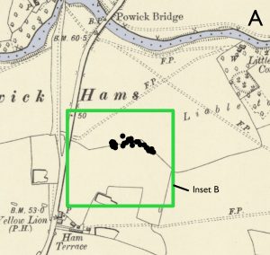
Map showing shot and other battlefield finds south of the River Teme, near the lane to Powick Bridge (created by British Archaeology magazine)
Our efforts focused on two main areas: the footprint of the new dual carriageway, which, being on a high embankment, was much larger than just the road itself, and a large lagoon established to its south as a flood compensation area. The lagoon area is close to Powick Church – possibly a Royalist observation post during the battle – where musket shots can still be seen in the fabric of the church tower. In more recent times, the lagoon area had been used for potato growing, an intensive form of agriculture that has heavily disturbed the upper alluvial horizon and mixed this material within higher layers. This resulted in an abundance of finds from the topsoil, which were not well preserved. The area along the line of the new road, however, produced higher quality data with finds sealed in their original context, still largely as they fell in September 1651.
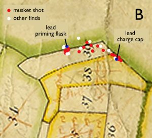
Map showing how battlefield finds seem to respect a field boundary on an 18th century estate map
In total, we recovered 50 lead shot of varying types – all compatible with weapons used in the Civil War period. As firearms weren’t standardised at this time, overlaps in shot sizes are inevitable, which can make the identification of weapons somewhat challenging. Despite this, we were able to determine 30 musket balls all of slightly varying size, ten pistol shots, five carbine shots and two buck shots (used in multi-ball loads).
Muskets were larger weapons used by the infantry (foot soldiers). Interestingly, most of the musket shot we recovered appears to have been for use with “bastard” muskets; a smaller, lighter, more compact version of the traditional musket that could be fired effectively without the need for a musket rest, rather than the larger medium or full bore weapons, though all sizes were present. Pistols and carbines were designed for use by cavalry soldiers as they were smaller and lighter – much more suitable for using whilst mounted on a horse.
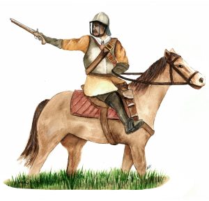 Parliamentarian cavalry soldier |
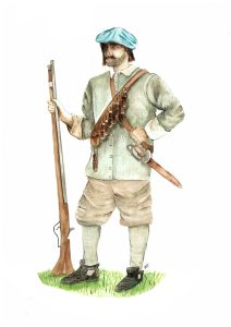 Royalist musketeer |
Interestingly, the largest spread of musket shot found within the upper alluvium was grouped together, along with other items, near a former boundary ditch some 140m east of the old route to Powick Bridge. Many of these show signs of their manufacture, but only some showed evidence of having been fired, so it is possible they had been dropped while this boundary was being used as a defensive position. This brings the battle into sharp focus; it is easy to imagine trembling fingers desperately trying to reload as the enemy advanced. This cluster could be a snapshot of the midst of the action in this area.
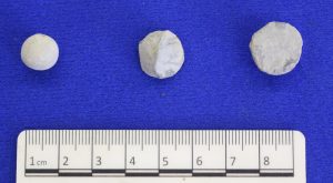
Pistol shot that was either dropped or fired without hitting a hard surface (left) and impacted lead shot (middle and right)
We also found powder charge caps, used to cover the top of a wooden cylinder containing a single charge of gunpowder. Musketeers wore 12 of these on a belt slung over the shoulder – known as a bandolier. These are often found on 16th to earlier 18th century battlefields, though usually in the topsoil rather than in the precise location where lost. Thanks to the good preservation here of battlefield deposits and archaeological techniques used, a cap was found sealed in the upper alluvium. It was among the cluster of musket shot by the field boundary mentioned above, along with a lead priming flask nozzle.
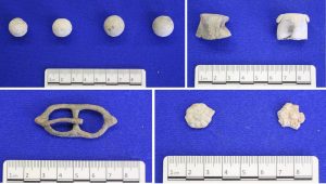
Clockwise from top left: Lead shot from a carbine (left) and musket (right), powder charge caps, strap ornaments and a buckle
Turning to finds from the lagoon area, there was a mixed assemblage of lead musket, carbine and pistol shot, as well as several horseshoes, 16th and 17th century silver coins, clay pipe, a buckle, harness mounts and at least one spur that could also be Civil War period losses. In addition to these were miscellaneous lead pieces that were possibly carried by troops for melting down and recasting into fresh shot. Though these items are not from a sealed layer, so may have moved some way from where they were originally dropped or lost, the emergence of personal effects begins to offer a tantalising glimpse into the people who made up the troops and their mixed social status.
What can these finds tell us about the battle? Find out in the final blog in this series – Royals and Rebels – What have we learnt?
This blog is based on an article by Derek Hurst and Richard Bradley, first published in the January/ February 2023 issue of British Archaeology magazine. And Bradley, R. and Hurst, D. (2023). Worcester Southern Link Road (Phase 4): Archaeological investigations 2018–2023. Worcestershire Archaeology unpublished report.
The project was undertaken by Worcestershire Archaeology for TACP (UK) Ltd, working on behalf of Alun Griffiths and Worcestershire County Council. Abbie Horton (Worcestershire Archaeology) created the reconstruction solider drawings. Photos and figures are copyright of Worcestershire Archaeology, unless otherwise stated.

An excellent, comprehensive report