Prehistoric wetland at Worcester Six
- 28th January 2022
Prehistoric wood is archaeological gold dust. So, what do you call Worcestershire’s first Iron Age wooden trackway and a whole wetland landscape? Exceptional.
This is not an archaeologist’s dream, but a site excavated for Worcester Six Business Park. Despite the unassuming location (alongside Junction 6 of the M5), in 2019 we uncovered human activity around an old stream stretching back over 3000 years. And thanks to the waterlogged soils, wooden stakes driven into the ground millennia ago can look as fresh as if they were sharpened yesterday.
Wood and other organic matter doesn’t usually survive in the ground for long. However, if the conditions are just right – the ground stays soaking wet, is frozen or totally dry – organic things can last for a surprisingly long time. This rarely happens. But when it does, our view of the past is upgraded from a fuzzy black and white photo to a crisp colour image. We’re no longer missing half the clues!
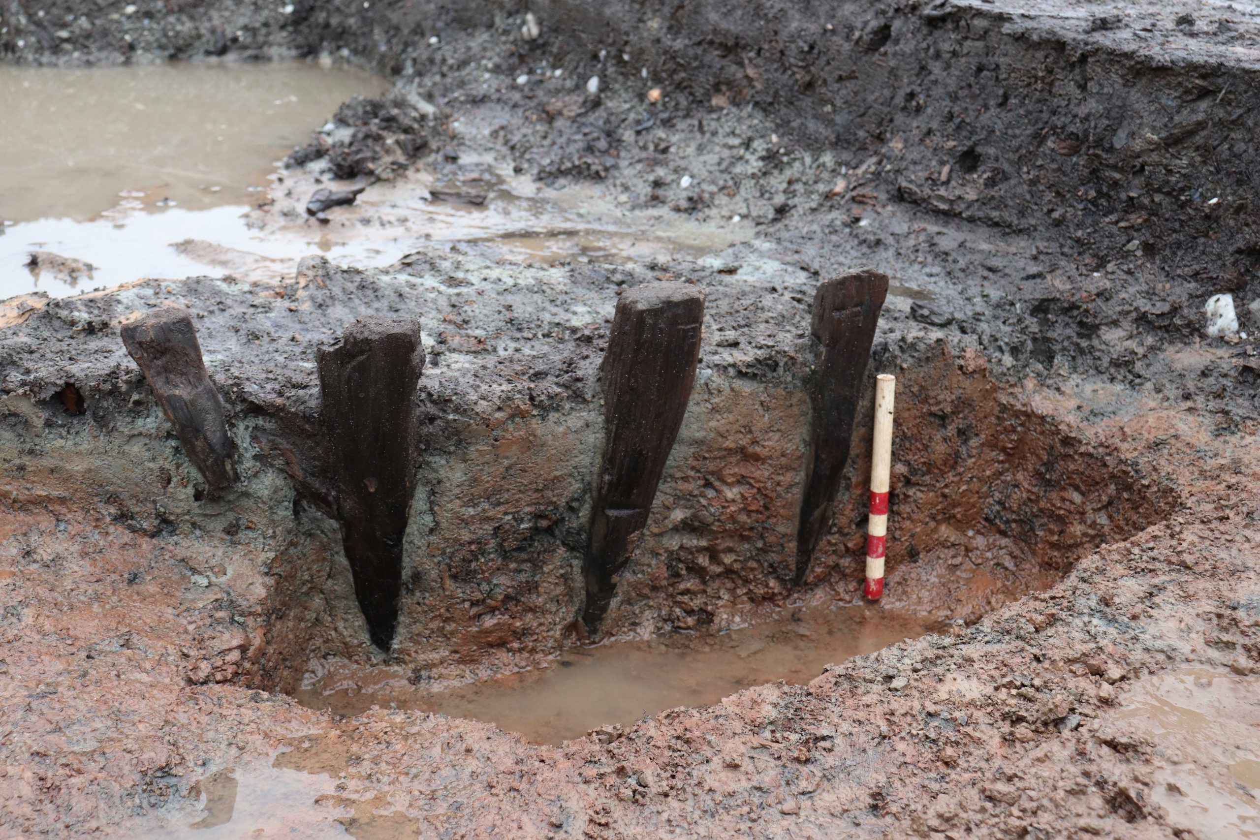
Row of Bronze Age stakes preserved by the waterlogged ground (20cm scale)
Babbling brook
Wind back the clock to 2400BC, the late Neolithic, and you’d see a broad meandering stream surrounded by woodland. The ground under your feet squelches. Because of this, few people have lingered here.
A thousand years later, the braided stream has confined itself into one channel. It’s now 1500BC, the Middle Bronze Age, and the world has changed. Plenty of trees are still visible from the 10m wide stream, but now there are areas of cleared ground and cereal crops too. The people here have different beliefs and ways of living to before. Small clusters of roundhouses, permanent settlements, dot the landscape away from the marshy areas near the stream. Yet this spot is still on the margins of everyday life – a land between places. Or is it?
Bronze Age
The first signs we have of people shaping this landscape are during the Bronze Age, when six rows of oak stakes were driven into the channel. As the stakes run down the middle of the channel, not across, they may have been to support fish traps. However, no basket or fence traps were found, so the stakes could be the remains of something else.
Later on, the banks of the channel were used for archaeologically elusive activities involving steam. Three ‘burnt mounds’ were created alongside or near to the wide stream. They’re essentially a mound of charcoal and fire cracked stones, usually with a water trough nearby. Archaeologists generally agree that water was poured on top of hot stones to create steam. But why is harder to answer – were they sweat lodges, or perhaps sites for cleaning fleeces, working plant fibres or wood, cooking or even brewing?
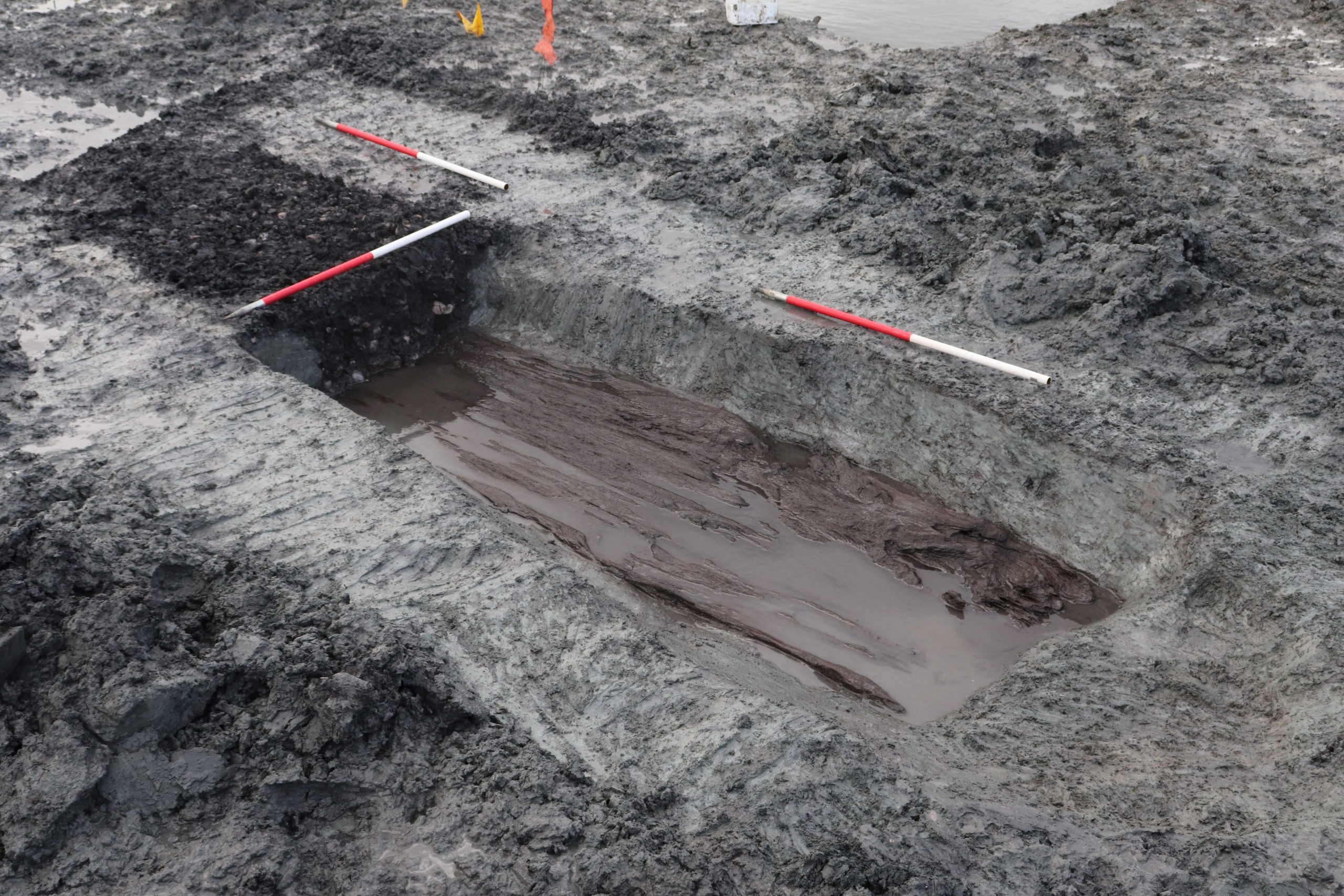
Large timber lined trough, half excavated to show fill of burnt material (3 x 1m scales)
Intriguingly, sweet smelling cherry and apple wood was added to the fires, alongside alder and oak. One of the burnt mounds (the largest we’ve ever found, at 24m by 35m) also had a row of stakes and a roundhouse nearby. The stakes would have formed a good windbreak and the roundhouse is on damp ground making it unlikely to have been a home. Whether practical, social, spiritual or a combination, it’s clear that the burnt mounds and wetland landscape were an integral part of people’s lives during the Bronze Age.
Slot being excavated across the largest burnt mound – a relatively thin but wide spread of charcoal and burnt stones
Iron Age
By the Iron Age, which began around 800BC, the burnt mounds had fallen out of use. As the corner of an enclosed settlement was found during the excavation, we know that people were living close to the wetland. We also know that they used this landscape, as they built several trackways and drove in a row of piles alongside the stream.
Two of the trackways were speedy attempts to create a drier path by chucking branches down, but the third required more of a plan and concerted effort. The track was 6m wide and ran for at least 12m. Cut branches were laid side by side along the trackway with small stakes at the edge, probably to stop them slipping. Archaeologists call this style of construction a ‘corduroy’ track as the branches look similar to ridges on corduroy fabric.
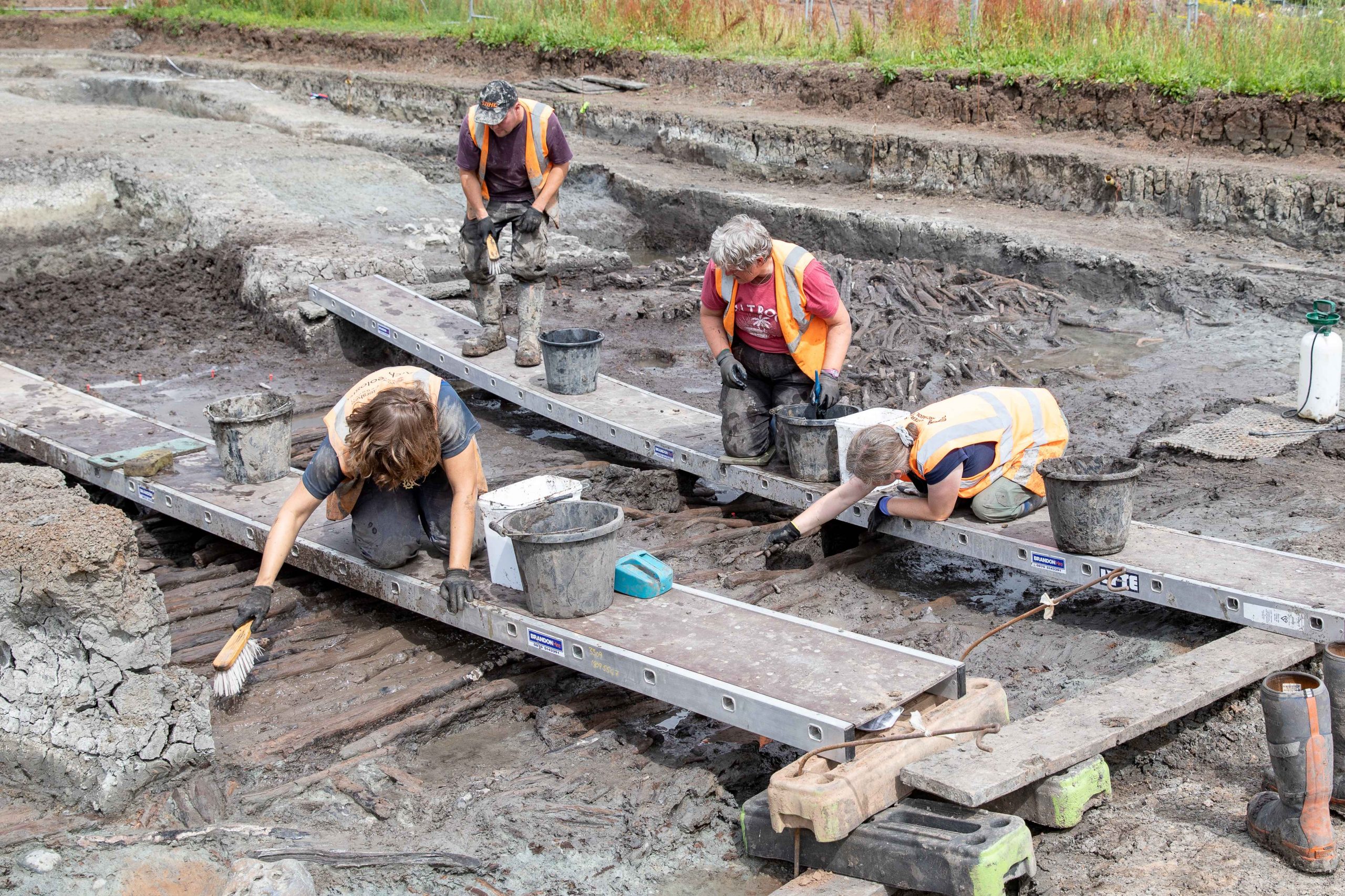
Careful excavation of the ‘corduroy’ Iron Age trackway from suspended boards
But there’s a conundrum: did the trackways cross the stream or stop at the edge? Flowing water cut new channels for the stream throughout prehistory, so it’s possible that the middle of these trackways was swept away. Alternatively, these wooden paths may be jetties to access the water’s edge rather than cross it.
We don’t know the answer, but we do have one last amazing find to share – a wooden spear or harpoon point. At least, that’s what it looks like. It was found on top of the corduroy track and it’s so well preserved that you can still see each carve mark. Over 2000 years ago, someone left this on the trackway. Had they just been fishing? Did they leave it by accident? Or perhaps the spear broke and the point was thrown away. Whatever the story, this moment in time became sealed by the channel until it was carefully released from the watery clay by our archaeologists. It is the little things like this – small, everyday moments trapped in time – that really bring the past alive.
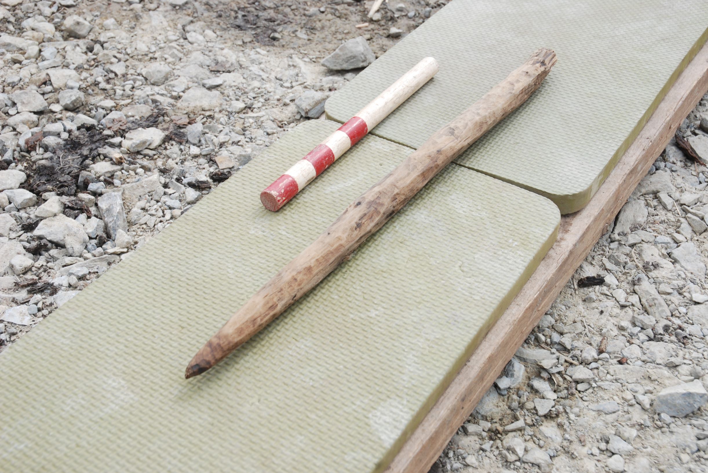
Finely carved spear or harpoon point (20cm scale)
So, next time you pass Junction 6 of the M5, think of the spear’s owner, track builders and burnt mound creators. Remember that the stream of traffic and tarmac was once a wooded wetland. And perhaps ponder what will be there in another 3000 years’ time.
Acknowledgements
Thanks to Stoford Developments for funding the excavation at Worcester Six Business Park and Simon Griffin at Jacobs. Once analysis is complete, the site report will be made available online via the Archaeology Data Service. The finds will be donated to the county museum.
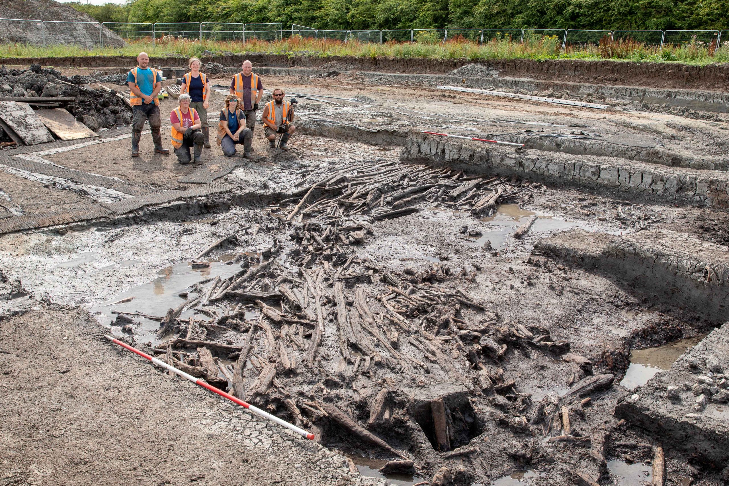
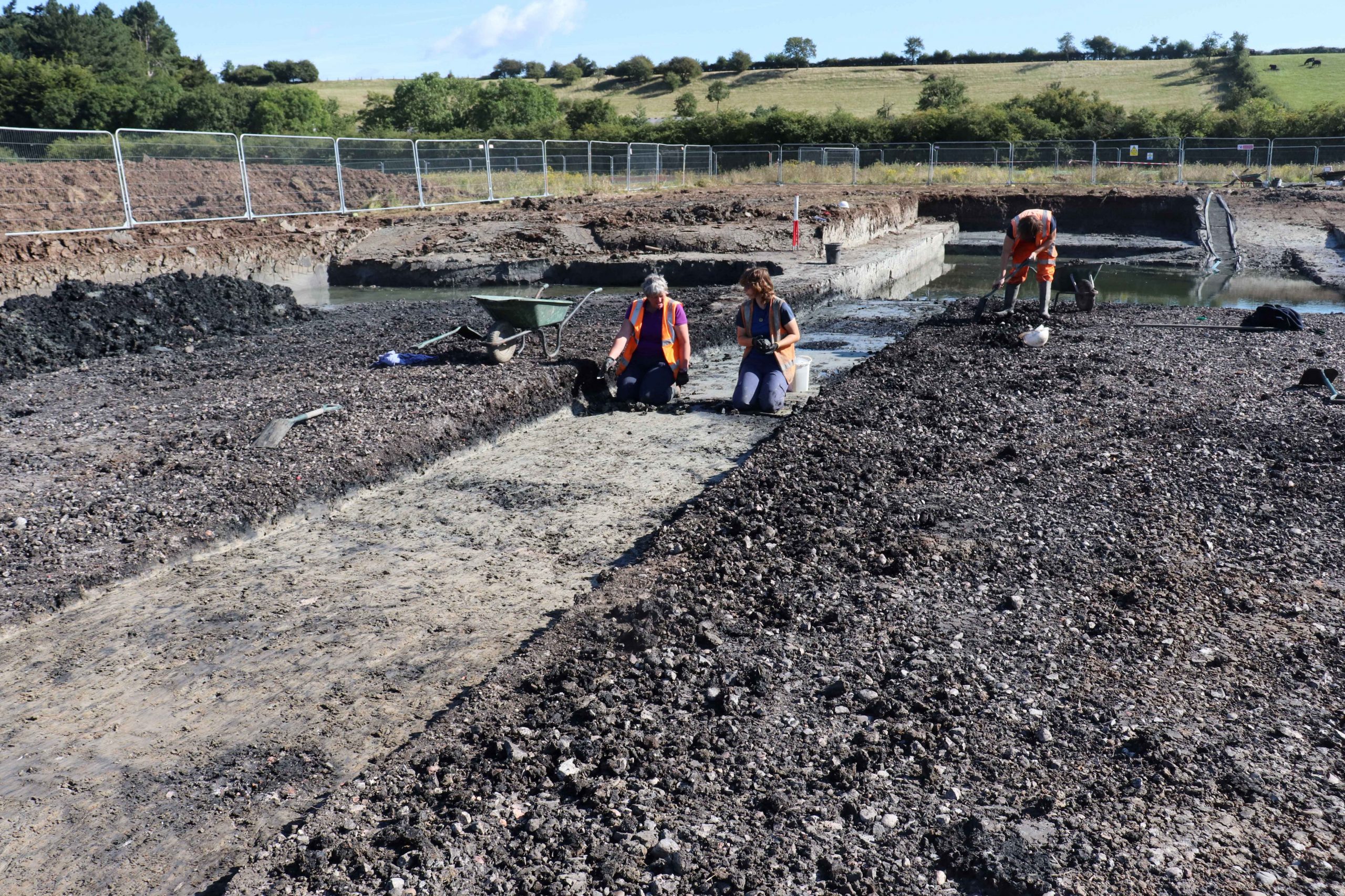
Field team with exposed wooden trackway (4m scale) – all photos copyright of Worcestershire Archaeology

Post a Comment