Treasures from Worcestershire’s Past: ~30~ crop marks captured through aerial photography
- 21st June 2014
This week Mike Glyde, Historic Environment Planning Officer, has chosen to highlight how Worcestershire’s crop marks can reveal the history buried beneath us:
As a general rule, most archaeological remains lie buried and unseen beneath our feet. It is hidden from view, passing away the decades, slowly fading away.
But the past is not always that keen to stay hidden, and given the right conditions can spectacularly reveal itself in astonishing clarity, all be it briefly, but from a vantage point most of us will never see.
I am of course waxing lyrical about crop marks, (not to be confused with crop circles, those enigmatic shapes of neatly trodden corn made by talented young farmers), which are marks in ripening cereal crops showing the variation in growing conditions created by the different character of soils on long ploughed level archaeological sites. These are my personal Treasures of Worcestershire, and for a number of years I combined my pleasure of flight, photography and archaeology to add to your record of this fantastic source of information.
Worcestershire is made up of diverse landscape, but the two principle river corridors of the Severn and Avon Valleys, and the glacial terraces of Bredon Hill and Broadway provide the ideal conditions for these long lost sites to appear, like ghosts during a few fleeting days in summer.
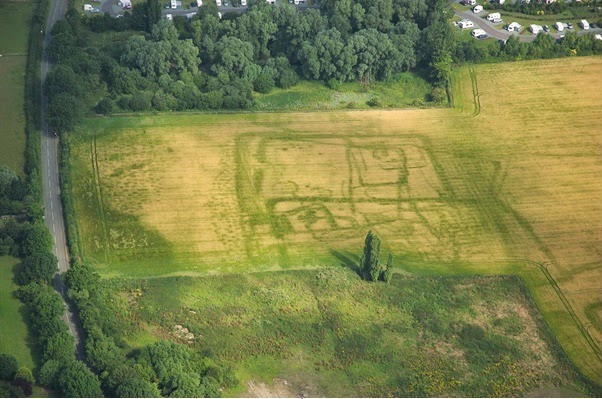
An aerial photograph taken by Mike Glyde of crop marked enclosures, pits and other features near Broadway, Worcestershire.
In simple terms crop marks form by a process of differential growth caused by soil moisture deficit. A cereal plant grows better over moister more humic soil than free draining sandy soil. Therefore where you have a site containing the remains of ancient ditches, pits and walls below the plough soil, this can, in the right conditions affect the growth rate of the crop above it. Where cereal is growing over ditch filled with finer more humic material than the surrounding sands, the plants will grow taller, stronger and take a little longer to ripen. The opposite is true for buried hard surfaces like walls and metalled tracks. In an old fashioned normal summer, we have extended periods of dry weather (don’t laugh) and the surrounding natural soil and geology dries out. By late June, when the crop ripens and begins to turn yellow, those plants growing over the archaeology may take a little longer to ripen, as they have more moisture to draw upon.
Given good conditions these crop marks can create a plan of the buried features in astonishing clarity, such as the palimpsest of enclosures and pits near Broadway. The problem is you can only record these from the air and so most people never witness them first hand. I count myself lucky to have experienced these normally hidden landscapes showing off first hand.
Archaeologists can then use these photographs to create accurate scale plans of the site using complex image rectification software.
The Historic Environment Record holds around six thousand aerial photographs of a huge range of sites, from prehistoric enclosures, Roman Roads, deserted medieval villages, post medieval fowl decoy ponds and WW2 defensive. Many of these sites have been rectified and are displayed on the counties Historic Environment GIS, and can be viewed at The Hive.
