1910 Land Valuation Survey
The Valuation Office Survey of 1910 resulted in the creation of a snapshot of land across the county of Worcestershire, in common with other counties in England, and the associated Valuation Summary books are to be found at the Hive in Worcester. An on-going project is transcribing these books for each civil parish in the county of Worcestershire: although all 40 columns of information presented in the Summary books were supposed to be completed at the time, it is often just the first nine columns which have been fully completed for each parish, but these are the most useful to the local historian.
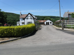
Photograph showing a property in the parish of Alfrick covered by the 1910 Land Valuation Survey.
A series of booklets is being prepared, one for each parish, presenting the transcribed data, indexes for owners, occupiers and places, along with a brief analysis of the transcribed data, drawing on sources such as geology of the area, the 1911 Census, and agricultural statistics for the parish. An appendix in each booklet also directs the interested reader to more detailed sources from the survey.
To date, some 136 booklets have been completed (free to download below), out of an estimated total of 243 parishes. The Archive service has a list of the available booklets, and more will be added as the Project progresses.
We would be very grateful for your feedback on this project. If you would like to make a comment or have any questions regarding it please get in touch with us via our Contact Us page.
If you would like to support the work of the Worcestershire Archive and Archaeology Service, you can make a small contribution via our Donate page.